Source: Corpus Christi, Texas, Jesse Allen, NASA
Practice working the distance formula in a problem situation.
A calculator, paper, and pencil are needed.
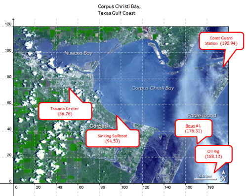
The Coast Guard station at Port Aransas, Texas, sends boats and helicopters to assist in rescue operations around the Texas Gulf Coast. They can fly directly from point to point, and sometimes they can go directly from point to point in a boat.
Use the map of Corpus Christi Bay to find the distances between locations listed in the table that the Coast Guard helicopter or boat might need to travel during rescue missions.
Source: Corpus Christi, Texas, Jesse Allen, NASA
Click on the blanks to reveal the answers.
Corpus Christi Bay |
||||
From |
Coordinates |
To |
Coordinates |
Approximate Distance by Helicopter or Boat |
Coast Guard Station |
Interactive button. Assistance may be required. _____ (195, 94) |
Oil Rig |
Interactive button. Assistance may be required. _____ (188, 12) |
|
Oil Rig |
Interactive button. Assistance may be required. _____ (188, 12) |
Buoy #1 |
Interactive button. Assistance may be required. _____ (176, 31) |
|
Buoy #1 |
Interactive button. Assistance may be required. _____ (176, 31) |
Trauma Center |
Interactive button. Assistance may be required. _____ (56, 76) |
|
Coast Guard Station |
Interactive button. Assistance may be required. _____ (195, 94) |
Sailboat in Distress |
Interactive button. Assistance may be required. _____ (94, 53) |
|
Sailboat in Distress |
Interactive button. Assistance may be required. _____ (94, 53) |
Trauma Center |
Interactive button. Assistance may be required. _____ (56, 76) |
|
Trauma Center |
Interactive button. Assistance may be required. _____ (56, 76) |
Coast Guard Station |
Interactive button. Assistance may be required. _____ (195, 94) |
|