 Watch this video for a brief introduction to the types of air masses.
Have you ever heard a weather forecaster say the following on the evening news?
"A huge mass of Arctic air is moving toward the United States, bringing freezing temperatures."
Or
"A warm front is heading toward our area causing temperature to rise."
What is an air mass? What is a front? In the next two sections, we will explore the answers to these questions.
Watch this video for a brief introduction to the types of air masses.
Source: Air Masses that Affect North America, BriMarie243, YouTube
An air mass is a large body of air that has similar temperature, moisture (humidity), and air pressure throughout. Air masses are classified by two characteristics: temperature and moisture (humidity.) An air mass gets its moisture and temperature characteristics from the area over which it forms. These areas are called "source regions." The characteristics of these air masses are represented on maps with a two-letter symbol. The first letter indicates the moisture characteristic of the air mass (maritime or continental), and the second letter represents the temperature characteristic of the air mass (arctic, polar, or tropical.)
Maritime (m) - forms over water; wet
Continental (c) - forms over land; dry
Arctic (A) - forms over the Arctic regions; extreme cold
Polar (P) – forms over the Polar regions; cold
Tropical (T) - develops over the tropics; warm
The following map shows the source regions for air masses that influence weather in North America. Click on each symbol to learn more about the air mass.

Global wind patterns affect how air masses move. Prevailing westerlies are the major wind belts in the continental United States. The prevailing westerlies generally push air masses from west to east. For example, continental polar masses from central Canada enter the United States between the Rocky Mountains and the Great Lakes. These cold, dry air masses are blown east and affect the weather in the central and eastern part of the United States.
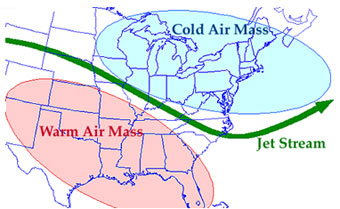
About 12 km above the surface of the Earth is a fast-flowing stream of air known as the jet stream. Jet streams form at the boundaries of two adjacent air masses that have significant differences in temperatures. Because of the effect of the Earth's rotation, the streams blow west to east at speeds of 200 to 400 kilometers per hour. Airplanes are aided by a jet stream when traveling east; it helps them save fuel and time. If a plane is flying west against and into a jet stream, it is slowed down.
Sources of images used for this section as they appear, top to bottom: