 Watch this video to see fronts and pressure systems on a weather map.
 Meteorologists are scientists who study the causes of weather and try to predict it. Meteorologists collect and interpret data from a variety of sources in order to predict the weather. These sources include local weather observers, instruments carried by weather balloons and satellites, and weather stations around the world. Radar is used to find the location, movement, and intensity of precipitation. Meteorologists use maps, charts, and computers to analyze weather data. In the United States, the National Weather Service (NWS) and the National Oceanic and Atmospheric Administration (NOAA) collect and analyze weather data.
Watch this video to see fronts and pressure systems on a weather map.
Source:How To Predict The Weather:
How To Predict Weather Fronts & Pressure Systems,
expertvillage, YouTube
 You try! Label the following map.
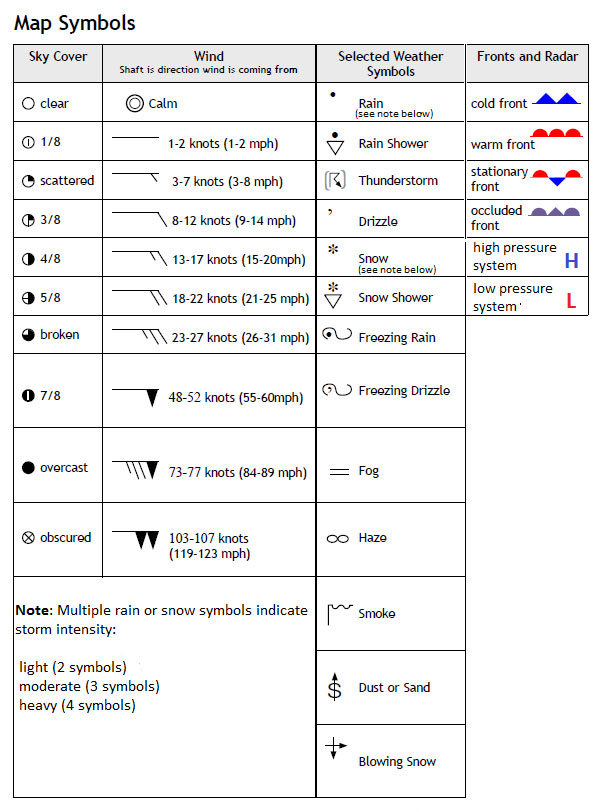
Weather maps also include data collected from weather stations. Look at the table below. It shows you the most common weather map symbols.
Weather conditions collected at a weather station are represented by a combination of the weather symbols. The image below explains what each part of the symbol means.
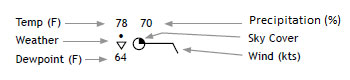
The conditions at the weather station where this data was collected are as follows:
Temperature: 78 °F
Weather: Rain showers
Dew Point: 64 °F
Precipitation: 70% chance
Sky cover: Scattered Clouds
Winds: From the east blowing 9-14 mph
You try!
Use the weather station data below and the chart above to complete the chart.
Sources of images used for this section as they appear, top to bottom: