
Which type of boundary is dependent upon the presence of a major geographic feature?
A. Natural
Correct! Natural boundaries only occur when a river, mountain, ocean, forest, or other major geographic feature is present.
B. Political
Incorrect. Political boundaries can be established without any obvious natural barriers present.
Incorrect. Political boundaries can be established without any obvious natural barriers present.
C. Cultural
Incorrect. Cultural boundaries tend to overlap and are usually not bound by natural features.
D. Social
Incorrect. Social boundaries are between people and have little to do with property.
According to the map of the Middle East above, which of the following statements is true?
A. Iran shares the largest portion of its border with Pakistan.
Incorrect. The largest portion of Iran’s border is shared with Iraq.
B. Yemen shares a border with Somalia.
Incorrect. Although Yemen and Somalia both have a common body of water as their border, they are located on different continents.
C. Saudi Arabia’s Western border is the Red Sea.
Correct! The entire western coast of the Saudi Arabia borders the Red Sea.
D. The border between Iran and Iraq runs East to West.
Incorrect. The border between the two countries runs north to south.
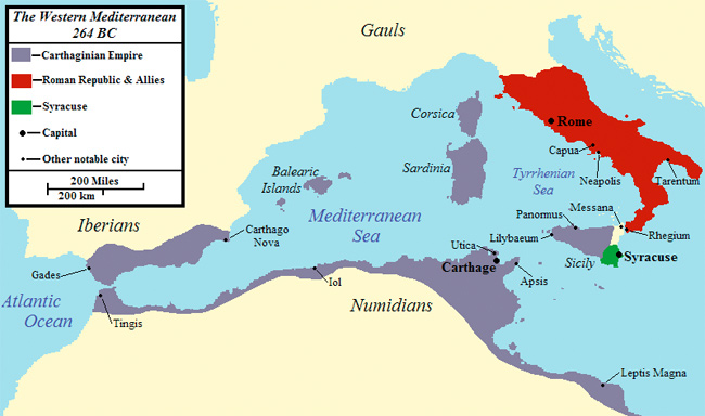
It can be concluded from the map above that the Punic Wars were most likely fought over control of trade routes in the –
A. Atlantic Ocean
Incorrect. The map shows that both empires controlled land around the Mediterranean, not the Atlantic.
B. Mediterranean Sea
Correct! The Mediterranean Sea was essential in the success of both empires.
C. Continent of Africa
Incorrect. Carthage was only in North Africa and Rome had little control in the area before the Punic Wars.
D. Adriatic Sea
Incorrect. Location is not indicated on the map.
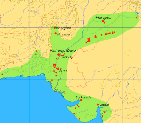
It can be inferred from the map above that in ancient times, the Indus River most likely served as a –
A. trade route
Correct! The location of two major cities along the Indus River indicates that it was used as a trade route.
B. defensive barrier
Incorrect. The Indus River was located in the middle of the civilization’s territory and did not act as a natural defense from an external enemy.
C. mountain pass
Incorrect. The Indus is a river located in a valley, not between two mountains.
D. political boundary
Incorrect. The river was the heart of the civilization, not the outside boundary.
Use the diagrams and your knowledge of social studies to answer the following question.
Diagrams of Historical Cities
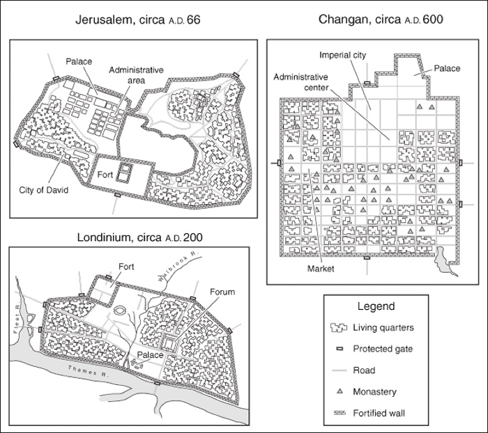
It can be concluded from the diagrams above that a common characteristic of these historical cities is that they —
A. all encouraged regional migrations
Incorrect. The walls surrounding these cities are barriers that discouraged migration.
B. were all easily accessed by outsiders
Incorrect. These historical cities were not accessible because of natural or man-made barriers.
C. were all able to export raw materials
Incorrect. The diagram does not reflect the exportation of any raw materials in any of the historical cities.
D. all had secure living environments
Correct! Each one of these cities had fortified walls that provided security for the inhabitants.